Fort Snelling
"I don't think we need forts in the United States anymore. Because their usefulness is no longer beneficial to us today. And so I think we've outgrown those structures of colonial dominance over Native American people. If we expect Native American people to be a part of and proud of who they are and a part of American society, we need to start to make concessions, historical concessions of reconciliation."
Dr. Clifford Canku, Sisseton Wahpeton community of Dakota, 2010
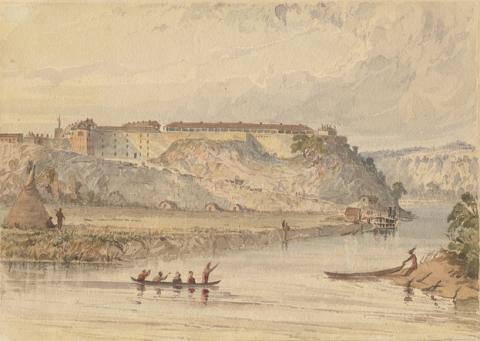
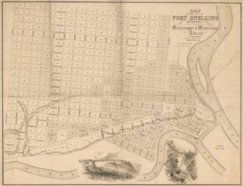
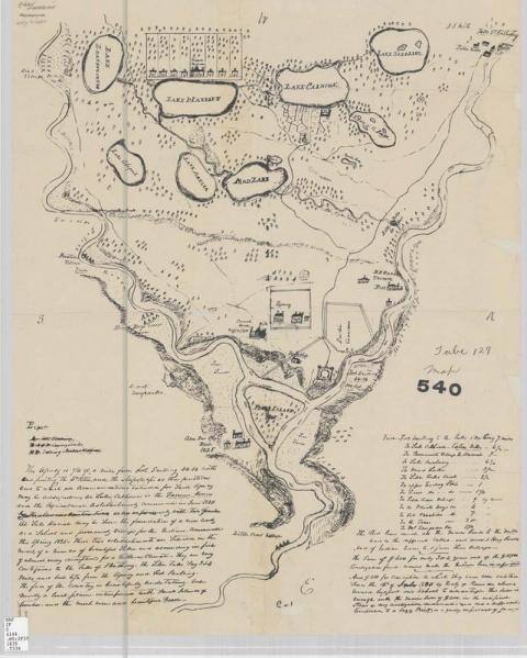
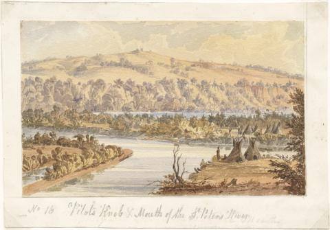
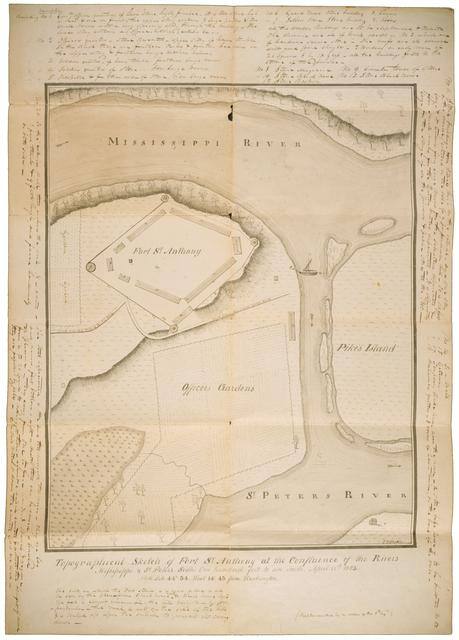
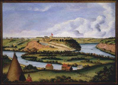
The junction of the Mississippi and Minnesota Rivers is a place of major social, cultural, and historical significance to all people inhabiting the region, a place whose history evokes both pride and pain. For Dakota people it is a historical gathering place, the site of the Bdote creation story, and a place of internment and exile after the U.S.-Dakota War of 1862.
The site was the crossroads of two major river highways of the fur trade, one of the most lucrative businesses of the 19th century. After the War of 1812, the U.S. government established its strategic presence at the river junction with the arrival of military forces and an Indian agent, whose goals were to promote and protect the interests of the United States in the region's fur trade and to gain the friendship and cooperation of Indian communities. The fort and its Indian Agency became a foothold of U.S. expansionism in the territory that would become Minnesota.
Theme:
Shared History
Permissions beyond the scope of this license may be available at Copyright and Use Information.
Bibliography
Hall, Steve. Colossus of the Wilderness. St. Paul, MN: Minnesota Historical Society Press, 1987.
Resources for Further Research
Websites
The Park Service must leave Coldwater Spring. MinnesotaHistory.net
Primary
Fort Snelling in 1823, Heckle's map breakdown. Minnesota Historical Society Collections.
Henry H. Sibley Papers, Minnesota Historical Society Manuscript Collections.
Lawrence Taliaferro Papers, Minnesota Historical Society Manuscript Collections.
Secondary
Date, Steve. A Visual Visit to Fort Snelling.
Mato Nunpa, Chris. Fort Snelling, U.S. imperialism and the Dakota People. Twin Cities Daily Planet.
Ziebarth, Marilyn. A Fort Snelling Calendar. Minnesota History. Fall, 1970.
Historic Sites
Key People

Henry Leavenworth
In 1805 the U.S. Army ordered Lt. Zebulon Pike to explore the Mississippi River and select potential sites for future military posts. When he arrived at the junction of the Mississippi and St. Peters (the present-day Minnesota) rivers, Pike made a treaty with several local Dakota representatives and acquired land on which he promised a U.S. trading post would be built. The trading post was never constructed, but following the War of 1812 the U.S. government sought to firmly establish its presence and stamp out any existing British influence in the Northwest Territory by building a fort at the river junction. The first troops arrived in 1819 under the command of Leavenworth. In 1820 he initiated the construction of Fort St. Anthony, which was later called Fort Snelling.
A few years later, he led U.S. troops in the first military expedition against a Great Plains Indian nation, the Arikara. While in the West he built military posts, one of which was Fort Leavenworth, established in Kansas in 1827. In 1833 he received the full rank of brigadier-general.
By 1834, he was commanding an expedition of the U.S Regiment of Dragoons in Indian Territory where hoped to create relationships between the United States and the Comanche, Kiowa, and Wichita nations. He died on this expedition in 1834.
Married three times, Lake Harriet, in Minneapolis, Minnesota, is named for his last wife, Harriet Lovejoy.

Josiah Snelling
By 1825, under Col. Snelling's leadership, the fort was completed, and was renamed Fort Snelling by the U.S. War Department in honor of his efforts.
Related Images

Fort Snelling in 1848
A view of Fort Snelling and the surrounding area as it looked in 1848 by Seth Eastman.

City at Fort Snelling
This map drawn by Thomas Moncure in 1857 shows the city that Franklin Steele planned to build on the Fort Snelling Military Reserve. Steele purchased the reservation from the United States government earlier in the same year

Taliaferro's Drawing of Fort Snelling
Lawrence Taliaferro's drawing of the area around Fort Snelling in 1835 detailing different villages, lakes, trading stores, and the agency. To zoom in on the map, click here.

Eastman, Pilot Knob
A painting done by Seth Eastman in 1866-48. It shows the site of Dakota creation, B'dote, where Fort St. Anthony (ne: Snelling) was later built.

Joseph Heckle Map
A view of construction at Fort St. Anthony, now known at Fort Snelling, in 1823. Originally, Zebulon Pike treatied for this location at the confluence of the Minnesota and Mississippi Rivers in 1805. It wasn't until 1819 that the U.S. military established a site, when Colonol Henry Leavenworth moved his Fifth Infantry Regiment from Detroit to the site. Many soldiers reported extremely poor conditions at the fort, but things improved a bit with contruction of soldiers' quarters 1823. For a breakdown of the map, see here
Related Documents


Josiah Snelling Papers
This personal diary documents events both significant and mundane in the life of Colonel Josiah Snelling, commanding officer at Fort Snelling from 1821-1825, and again from 1825-1827 before his death in 1828. The majority of the journal's entries encompass the spring and summer of 1827. They are supplemented by miscellaneous entries and memos dated 1825-1828. Among them are a speech by the Ojibwe chief Strong Earth, a statement of conditions for a duel, ledgers of debts Snelling paid and incurred, a reference to the re-burial of Snelling's deceased daughter, Elizabeth, and a few detachment orders.